
Straßdorf (Schwäbisch Gmünd)
|
Strassdorf
City of Schwäbisch Gmünd
|
|
|---|---|
.png) |
|
| Height : | 406 m |
| Area : | 13.7 km² |
| Residents : | 3721 (Dec. 31, 2014) |
| Population density : | 272 inhabitants / km² |
| Incorporation : | April 1, 1972 |
| Postal code : | 73529 |
| Area code : | 07171 |
 Location of Straßdorf in Schwäbisch Gmünd
|
|
Straßdorf is a district of Schwäbisch Gmünd in Baden-Württemberg .
geography
Geographical location

The district of Straßdorf is about two kilometers south of the city of Schwäbisch Gmünd on an Albvor plain about 420 meters above sea level.
geology
195 million years ago the dry and hot mainland period came to an end in Central Europe. The sea flowing in from the north deposited about 800 m thick layers of sediments in the next 60 million years ( Jurassic period ). The sediments of the Jurassic period are divided into three layers. In the area of the district, the top layer ( Upper Jura ) and middle layer ( Middle Jura ) were removed over time. The bottom layer ( Lower Jurassic ) remained. In this 80 m thick layer there are numerous shell remains of the oysters and ammonites living in the Jurassic Sea. During the last Ice Age around 10,000 years ago, sand and dust storms blew loess from the Rhine Valley . Loess loam was then formed through weathering and decalcification . This forms the top layer above the very hard rock of the Lower Jura, especially in the northeast of Straßdorf.
structure
The district consists of the main town Straßdorf, the suburbs Metlangen, Reitprechts and Schönbronn as well as some individual farms.
climate
Measurements in the period from 1939 to 1961 showed an average annual precipitation of approx. 1000 mm per m² and year and an average annual temperature of 7.3 ° C. In the period from 1961 to 1990 there was an average annual precipitation of approx. 1015 mm per m² and year and an average annual temperature of 7.8 ° C. The climate is therefore classified as temperate-montane. The measurements took place at climate stations in Schwäbisch Gmünd and Geislingen / Stötten.
history
The name of the community probably goes back to a Roman road that led from the nearby Schirenhof Roman fort to Nenningen . The fort existed from around 150 AD. The street led through the town in the area of today's streets Kastellstrasse, Wallenstrasse ( Welsche Gasse) and Alemannenstrasse. Hence the name Straßdorf (village on the road). The road continued via Waldstetten and the Christental to Nenningen. In 1917, Roman foundation walls and a signet ring were found in the district of Straßdorf. The remains of the wall were dated to this time (2nd century).
The first reliable mention of the municipality goes back to the year 1269. In a conciliation letter from the Lorch monastery , Dietrich, the vice pastor of Straßdorf, is mentioned as "Dietrici viceplebani de Strasdorf".
On April 1, 1972, Straßdorf was incorporated into the city of Schwäbisch Gmünd.
Population development
|
|
politics
mayor
1500 to 1803 (Rechbergische and Gmündische Schultheiße)
Since Straßdorf is ruled by the Rechberg noble family and by Schwäbisch Gmünd from the end of the 15th century, there are both Rechberg and Gmündische Schultheiße until 1803.
|
|
after 1803 the following mayors and mayors were in office:
|
|
Culture and sights
Buildings
The oldest components of the " Old Church " go back to the year 1100. The church became too small at the beginning of the 20th century. Due to the preservation order, the church was neither demolished nor rebuilt. The Church of St. Cyriakus was therefore rebuilt elsewhere in 1914/1915. One of the oldest buildings has been preserved in the village. In 1718/1719 the Marienkapelle was built on the northern edge of the village.
In 2002, the path to art sculpture path was set up on the plateau north of Straßdorf . a. by Jakob Wilhelm Fehrle , Eckhart Dietz or Fritz Nuss shows.

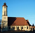
Old Church (Friedhofskirche)
St. Cyriacus Church

Adolf Bidlingmaier: Age , stone relief 1939 on ways to art

The former station of the disused Hohenstaufenbahn


Personalities
Sons and daughters of the church
- Georg Mühleisen (1768–1846), city scholar of Gmünd
- Josef Bidlingmaier (1870–1967), watch manufacturer ( Bifora watches )
- Anton Nägele (1876–1947), historian and theologian
- Hans Eisele (1876–1957), diplomat, journalist and writer (born in Metlangen)
- Augustinus Hieber (1886–1968), "pastor of blessings from the Allgäu"
literature
- From the past of Straßdorf Reitprechts and Metlangen - A home book . Einhorn-Verlag, Schwäbisch Gmünd 1993, ISBN 3-927654-02-7 ( online ).
- Klaus Graf : From the local history of Straßdorf . In: einhorn-Jahrbuch 1982, pp. 207–214 ( Commons ).
- Anton Schurr: From the Chronicle of Straßdorf . 1951.
Web links
Individual evidence
- ^ Rechberg - A home book: Ortschronik Rechberg, district of Schwäbisch Gmünd . Einhorn-Verlag, Schwäbisch Gmünd 2004, ISBN 3-936373-16-7 .
- ↑ Württembergisches Urkundenbuch, Volume VII., No. 2041, Pages 4–5 .
- ^ Federal Statistical Office (ed.): Historical municipality directory for the Federal Republic of Germany. Name, border and key number changes in municipalities, counties and administrative districts from May 27, 1970 to December 31, 1982 . W. Kohlhammer, Stuttgart / Mainz 1983, ISBN 3-17-003263-1 , p. 456 .
- ↑ Bulletin Schwabisch Gmund - Rechenberg, Straßdorf, Metlangen, riding Precht
- ↑ Project page "Paths to Art"
